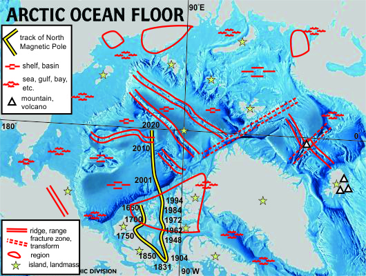
Alpha Ridge
Extending from Ellesmere Island across the Western
Arctic
Baffin Bay
between Canada and Greenland
Baffin Island
largest island in the Canadian Arctic
Banks Island
westernmost island of the Canadian Arctic
Barents Shelf
Shelf north of European
Russia
Beaufort Sea
north of Alaska
Bering Strait
between Siberia and
Alaska
Brooks Range
northernmost mountain range of Alaska
Canada Basin
largest basin, in the
western Arctic
Chukchi Plateau
north of the Bering
Strait
Chukchi Sea
far eastern Siberian margin
Devon Island
between Ellesmere and Baffin islands
East Siberian Sea
as the name says -
east Siberian (east of New Siberian Islands)
Ellesmere Island
northernmost Canada, location of Eureka Orogeny and Pearya terrane
Eurasian Basin
basin between mid-Arctic
Ridge and Lomonosov Ridge
Eyjafjallajökull
erupted April 2010, shutting down air traffic over much of Europe
|
Fran Basin
Arctic Ocean floor off Barents
Shelf
Franz Josef Land
archipelago along
the edge of the Barents Shelf east of Svalbard
Greenland
rifted off North America
Hekla
central Icelandic volcano
Iceland
on mid-Atlantic Ridge
Jan Mayen fracture zone
major fracture
zone across mid-Atlantic Ridge between Iceland and Spitsbergen
Jan Mayen Island
volcanic hot spot island on Jan Mayen Fracture Zone between
Greenland and Norway
Kara Sea
east of Novaya Zemlya
Kola Peninsula
northeastern Scandinavia and northwesternmost Russia
Laptev Sea
between Taimyr Peninsula and
New Siberian Islands
Lena Delta
on Laptev Sea, best found by
projecting the mid-Arctic Ocean ridge to its Euler pole
Lomonosov Ridge
splits Arctic Ocean basin in two, extending from Ellesmere Island to New
Siberian Islands
Makarov Basin
between Lomonosov Ridge and
Alpha Ridge-Mendeleev Cordillera
Mendeleev Cordillera
elevated portion of the Siberian side of the Canada Basin
Mid-Arctic Ridge
extension of the mid-Atlantic Ridge north of the Svalbard fracture
zone
|
Mid-Atlantic Ridge
extending north
and south from Iceland
Nares Strait
narrow strait between Ellesmere
Island and Greenland
New Siberian Islands
archipelago between Laptev and East Siberian seas
North Pole
beside Santa's house
North Slope of Alaska
northern margin of
Alaska, north of Brooks Range
Norwegian Sea
northeastern Atlantic Ocean
Novaya Zemlya
northern extension of Ural Mountains, separating Barents and Kara
seas
Queen Elizabeth Archipelago
the northern islands of Canada (north of Baffin-Victoria-Banks
islands)
Severnaya Zemlya Archipelago
between
Laptev and East Siberian seas
Spitsbergen
on northwestern margin of the Barents Shelf
Surtsey
Island formed on south coast of Iceland by volcanic eruptions
in 1963
Svalbard fracture zone
separates mid-Atlantic
from mid-Arctic ridges, extending from Svalbard along the north of Greenland
Taimyr Peninsula
northernmost Russia (central Siberia)
Victoria Island
largest island in the
western Canadian Arctic
White Sea
northern European Russia |
